Page 1 of 1
Invalid Raster Elevations - yes to all button
Posted: Fri Feb 15, 2019 2:23 am
by AndrewPerth
Hello,
Just wanted to suggest that a "yes to all" button be added for this:
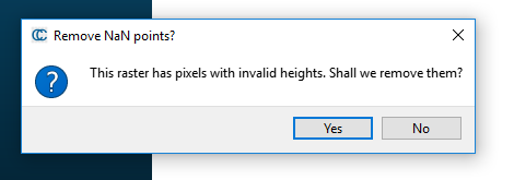
- Invalid elevations.PNG (8.22 KiB) Viewed 19716 times
Additionally, it may be useful to modify the yes to all for the coordinate translate/rescale. Having some logic in it to automatically rescale all the added points instead of asking again about the translate/rescale when the point in local coordinate system gets too large would save time. This would save time when loading point clouds that cover hundreds of kilometers.
kind regards,
Andrew
Re: Invalid Raster Elevations - yes to all button
Posted: Sat Feb 16, 2019 11:42 am
by daniel
Ok I added the "Yes to All" button to the invalid raster pixels (it will be available in the 2.10.2 version soon).
For the other one, can you be more explicit? What kind of logic are you expecting?
Re: Invalid Raster Elevations - yes to all button
Posted: Mon Feb 18, 2019 9:12 am
by AndrewPerth
Hi Daniel,
fantastic! that will really speed up loading in large numbers of raster files.
With the previous shift thing, honestly any logic that keeps me from having to hold down the enter key every time this pops up:
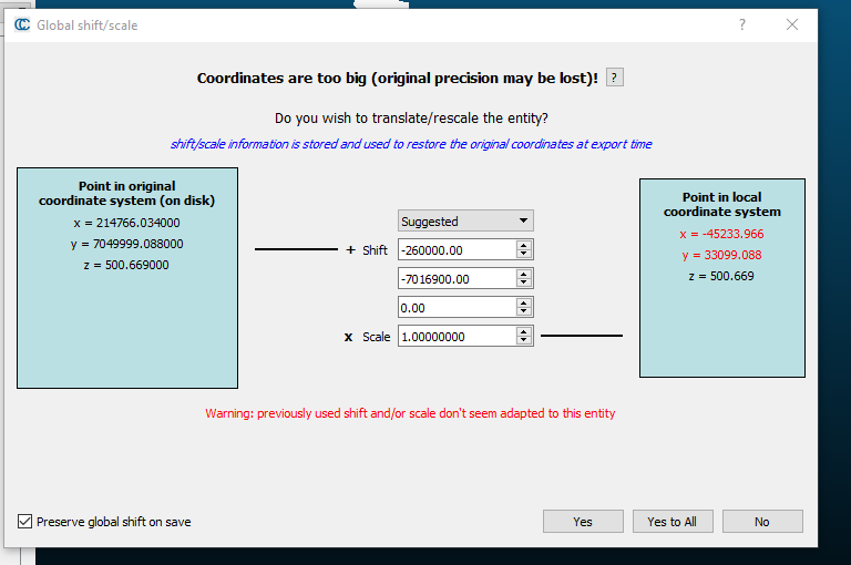
- previous shift2.PNG (26.41 KiB) Viewed 19677 times
I was wondering whether it would be possible to continue loading all the files in at the original assumed shift, and then doing an assessment of the extents of all the loaded files then globally shifting the lot again to the most efficient translation.
regards,
Andrew
Re: Invalid Raster Elevations - yes to all button
Posted: Mon Feb 18, 2019 9:52 pm
by daniel
Are you loading LAS files maybe? LAS files come with their own 'Shift', and this shift is used by default by CC.
The problem is that if your LAS files use all a different shift, then you are a bit 'forced' to validate each of them currently (especially if they don't 'solve' the accuracy issue as in your example...). Unless you use a shift value that actually solve the accuracy issue (i.e. keeping all values on the right 'black'), in which case CC should be able to use the same shift for all clouds.
Re: Invalid Raster Elevations - yes to all button
Posted: Thu Feb 21, 2019 4:21 am
by AndrewPerth
HI Daniel,
they were ASCII grid files. They just cover an area that if you were to put it all in a rectangle is about 50 km by 35 km. Therefore eventually the files end up being shifted to the coordinate values in my example picture where the x value wants to be -45,000 m and the y value wants to be 33,000 m. So the issue is specifically related to topographic data that covers huge expanses.
kind regards,
Andrew